Lesser Antilles bracing for Hurricane Isaac's impacts late this week
Hurricane Isaac will churn westward and bring strong winds and heavy rain to the Lesser Antilles during the second half of the week.
Isaac, the fifth hurricane of the 2018 Atlantic season, is located roughly 1,300 miles east of the Lesser Antilles as of early Monday morning.
Isaac will continue on a westward path toward the islands into midweek.
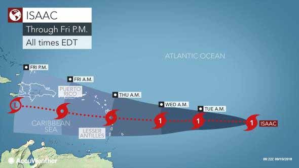
The hurricane is rather compact in size and this may make it susceptible to fluctuations in strength in the coming days.
AccuWeather meteorologists cannot rule out the possibility that it could reach Category 2 strength early this week.
Interests elsewhere across the Caribbean will want to keep close tabs on Isaac's track beyond the Lesser Antilles.
However, the storm is expected to encounter increased wind shear later this week.

Wind shear, or the the change in wind direction and/or speed with altitude, can rip apart small systems such as Isaac.
Exactly how much wind shear Isaac encounters will determine whether it retains hurricane strength or is a strong tropical storm as it passes through the Lesser Antilles.
Interests elsewhere across the Caribbean will want to keep close tabs on Isaac's track beyond the Lesser Antilles.
Accuweather
Isaac continues to be a tough storm to forecast, especially in terms of intensity forecasting. Satellite imagery this morning indicates that Isaac is a small hurricane. Small hurricanes have a notoriously bad habit of intensifying really quickly and then weakening just as quickly. Right now, however, Isaac is holding at a 75 mph hurricane.
The intensity forecast for Isaac, I think, is extremely difficult. As I already mentioned, small hurricanes like this one are very prone to quick changes in both strengthening and weakening. In addition, the intensity guidance is in poor agreement as solutions range from steady weakening from this point on to a majority of the guidance forecasting Isaac to remain a Category 1 hurricane to the HWRF model forecasting rapid strengthening into a Category 3 to 4 hurricane just as Isaac moves across the Lesser Antilles into the eastern Caribbean. My thinking is that Isaac will remain in the Category 1 hurricane range as wind shear values will remain at 10 knots or less from today through Tuesday. After Tuesday, the wind shear is expected to increase to 25-35 knots which should lead to Isaac weakening as it moves through the central Lesser Antilles and into the eastern Caribbean.
Those of you in Jamaica, the Cayman Islands, Belize and the Yucatan Peninsula might want to keep an eye on Isaac, just in case it starts strengthening again this weekend. The soonest Isaac might start affecting you is around next Monday and next Tuesday.
Crown Weather Services
For more information, check the daily Tropical Weather Outlook, click here.


