AT 1100 PM EDT...0300 UTC...THE CENTER OF HURRICANE RINA WAS LOCATED NEAR LATITUDE 17.2 NORTH...LONGITUDE 83.3 WEST. RINA IS SLOWLY MOVING TOWARD THE WEST-NORTHWEST NEAR 3 MPH...6 KM/H. THIS GENERAL MOTION IS FORECAST TO CONTINUE THROUGH TUESDAY...WITH A GRADUAL TURN TOWARD THE NORTHWEST EXPECTED ON WEDNESDAY.
MAXIMUM SUSTAINED WINDS HAVE INCREASED TO NEAR 80 MPH...130 KM/H... WITH HIGHER GUSTS. RINA IS A CATEGORY ONE HURRICANE ON THE SAFFIR- SIMPSON HURRICANE WIND SCALE. STRENGTHENING IS FORECAST DURING THE NEXT 48 HOURS...AND RINA COULD BECOME A MAJOR HURRICANE BY WEDNESDAY.
HURRICANE-FORCE WINDS EXTEND OUTWARD UP TO 15 MILES...30 KM...FROM THE CENTER...AND TROPICAL-STORM-FORCE WINDS EXTEND OUTWARD UP TO 115 MILES...185 KM.
Rina became a hurricane Monday afternoon and has increased into a category 2 hurricane this morning. Additional strengthening is likely, and Rina could become a major hurricane later today or Wednesday. - Will slowly move generally to the west-northwest for the next couple of days, in the direction of the Yucatan Peninsula - Could bring locally heavy rains...
Hurricane Rina lies 100 miles north of Honduras moving WNW at 3mph. Winds are 100mph and expected to strengthen tomorrow. Rina is expected to make landfall near Cancun, Mexico on Thursday night.
Invest 97 lies north of Curacao moving west at 19mph. Winds are 30mph. The NHC estimates a 40% chance that it will develop during the next 48 hours. Computer models predict that it will move NW toward the Gulf of Mexico and may become a hurricane by Friday.
AT 500 AM EDT...0900 UTC...THE CENTER OF HURRICANE RINA WAS LOCATED NEAR LATITUDE 17.3 NORTH...LONGITUDE 83.6 WEST. RINA IS MOVING TOWARD THE WEST-NORTHWEST NEAR 3 MPH...6 KM/H...AND A GRADUAL TURN TOWARD THE NORTHWEST WITH SOME INCREASE IN FORWARD SPEED IS EXPECTED OVER THE NEXT 48 HOURS. ON THE FORECAST TRACK...THE CENTER WILL BE APPROACHING THE EAST COAST OF THE YUCATAN PENINSULA BY THURSDAY MORNING.
REPORTS FROM AN AIR FORCE RESERVE UNIT HURRICANE HUNTER AIRCRAFT INDICATES THAT THE MAXIMUM SUSTAINED WINDS HAVE INCREASED TO NEAR 100 MPH...160 KM/H...WITH HIGHER GUSTS. RINA IS A CATEGORY TWO HURRICANE ON THE SAFFIR-SIMPSON HURRICANE WIND SCALE. ADDITIONAL STRENGTHENING IS FORECAST DURING THE NEXT DAY OR SO...AND RINA COULD BECOME A MAJOR HURRICANE BY TONIGHT OR EARLY WEDNESDAY.
HURRICANE FORCE WINDS EXTEND OUTWARD UP TO 15 MILES...30 KM...FROM THE CENTER...AND TROPICAL STORM FORCE WINDS EXTEND OUTWARD UP TO 115 MILES...185 KM.
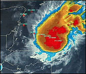
Hurricane Rina is a Category 2 Hurricane located at 17.4° N, 83.8° W with maximum sustained winds of 100 mph, gusting to 120 mph
Convection continues to build around the circulation of Rina and a gradual increase in strength is expected over the next 24 hours. Rina is the sixth hurricane of the tropical season and has reached Category 2 strength; Rina could become a major hurricane by Wednesday. Rina is located in the northwestern Caribbean Sea, approximately 210 miles southwest of Grand Cayman. Environmental conditions will remain somewhat favorable for strengthening in that the wind shear will be light and the sea surface temperatures are more than warm enough to sustain a system. However, one limiting factor for significant strengthening will be a lot of dry air perched over the Gulf of Mexico that could get drawn into the circulation and slow the strengthening process down.
Through the middle of the week, Rina will continue tracking slowly toward the west, north of the coast of Honduras. By the latter part of the week, a strong upper-level trough associated with a cold front will deepen across Texas toward the Gulf of Mexico, and we feel this will help to steer the tropical cyclone to the north and perhaps northeast. This movement could bring the tropical system near or over the Yucatan Peninsula of Mexico on Thursday or Friday. Some moisture from the storm could extend northeastward across Florida, Cuba or the Bahamas by the end of the week or this weekend, but at this time it is very questionable if the center of the storm will make it much farther north than the Yucatan Channel. However, residents of South Florida should monitor the progress of Rina very closely as some computer models do take the center of Rina over the Florida Keys or the southernmost tip of Florida later on Friday or Friday night.
The other area we are monitoring for potential development right now is a broad area of low pressure that is currently over the extreme southeastern Caribbean Sea. Although satellite imagery continues to show some shower and thunderstorm development associated with this low pressure center, it remains rather disorganized without a low-level center of circulation. This area of low pressure will bring some gusty showers and thunderstorms to the central and southern Windward Islands today as it continues to track westward. This low center should continue to track westward across the Caribbean later in the week, and some development will be possible once it reaches the western Caribbean.
The rest of the North Atlantic tropical basin will not support tropical development for at least the next few days.
Hurricane Rina Strengthens in Caribbean on Track Toward Yucatan Peninsula
Hurricane Rina strengthened to a
Category 2 storm on the five-step Saffir-Simpson scale as it
churned over Caribbean waters toward resorts on Mexico's Yucatan
Peninsula, the National Hurricane Center said.
Rina's top winds are 100 miles (160 kilometers) per hour,
up from 80 mph earlier, according to an NHC website advisory at
5 a.m. Miami time. It's the sixth hurricane of the 2011 Atlantic
storm season that runs from June through November.
"Strengthening is forecast during the next day or so" as
the storm spins over warm waters off the north coast of
Honduras, the center said. Rina may become a major storm later
today or tomorrow, the NHC said.
Mexico issued a hurricane watch from north of Punta Gruesa
to Cancun, which means hurricane conditions are possible within
the area and readied 1,130 storm shelters in the state of
Quintana Roo, which includes Cancun and Cozumel. The country
also declared a tropical storm watch for the east coast of the
Yucatan from Chetumal to Punta Gruesa, the NHC said.
Rina Nearing Resorts
Rina is forecast to approach Cancun in two days, then curve
east toward the west tip of Cuba by the weekend, the NHC's
tracking maps show. The system is about 320 miles east-southeast
of Chetumal, moving west-northwest at 3 mph.
The center forecasts Rina's winds will strengthen to at
least 120 mph, a Category 3 storm on the Saffir-Simpson scale
with the power to snap trees, blow down poorly built homes and
create a "high risk of injury or death to people, livestock and
pets due to flying and falling debris."
Hurricane-force winds of at least 74 mph extend 15 miles
from its core and tropical storm-force winds of 39 mph or more
reach out 115 miles, the NHC said.
The center is also monitoring a low-pressure system just
north of Curacao that's producing thunderstorms over the
southeastern Caribbean. The system has a 40 percent chance of
forming into a tropical cyclone in the next two days, the center
said in a weather outlook.
Exactly one year ago, on October 24th, 2010, Hurricane Richard mauled and mashed up south-central and western Belize. And tonight on the anniversary of that terrible storm, Belize is under hurricane watch for another: Rina.
Tonight Rina is a category one hurricane sitting on the northeast coast of Nicaragua and, which is about 350 miles east-southeast of Belize. The storm is heading northwest at 5 mph with maximum sustained winds of 75 mph.
NEMO has declared Phase II-Red 1, Hurricane watch from Belize City Northward to the Belize Mexican Border.
San Pedro will have voluntary evacuation starting at 6:00 am tomorrow and water taxis will not be allowed to bring travelers to the island.
School will also be closed for San Pedro and Caye Caulker tomorrow. The UB Gymnasium will be used as shelter for San Pedro and UB Scarlet Macaw for Caye Caulker. The Coast Guard will coordinate Caye Caulker evacuation.
Some of the public transportation in the North of the country will be disrupted to assist with coastal to inland evacuation. The public is to take note that this will affect their travel plans tomorrow.
Today, we went to NEMO Headquarters in Belmopan to get a threat assessment from Chief Met Officer Dennis Gonguez:..
Dennis Gonguez - Chief Met Officer "Yesterday Sunday at 3pm the eighteenth tropical depression of this year hurricane season formed over the northwestern Caribbean and by 9pm this system became hurricane Rina. The system strengthened rapidly during the course of today and now it's a category 1 hurricane."
"Conditions are favorable for this system to further intensify and quite possible we will be seeing a major hurricane east of us by Tuesday night. The present projection for landfall is north along the Yucatan Peninsula, north of the country of Belize. However there are some uncertainties in the track at this time, so we are thinking about issuing hurricane watches for Belize City northwards. We are considering declaring the first phase of the national emergency plan at 3 pm for Belize City northwards. That means hurricane conditions are likely within the next 48 hours."
"The ones out at the Cayes have to start to consider evacuation tomorrow and definitely on Wednesday, so it is more urgent the for the folks in the Cayes to be prepared for evacuation for Wednesday."
"This system has potential to become, like I said a major hurricane by tomorrow night and could impact us severely come late Wednesday or Thursday"
Forecasters say the storm is expected to make landfall within the next 48 hours.
NEMO remains on full alert and regular advisories will be available on local radio and television for further advisories from NEMO and the National Met Service.
Hurricane Rina is now a Category 2 storm, headed slowly west-northwest at 3 mph towards Mexico's Yucatan Peninsula. The most recent hurricane hunter mission was at 4:32 am EDT this morning, and the next aircraft is not due into the storm until this afternoon, so we'll have to rely on satellite estimates of the storm's strength until then. Recent satellite intensity estimates suggest Rina has leveled off in intensity, with no change in strength since the last hurricane hunter mission. A murky, cloud-filled eye is visible on visible satellite loops right now. Rina also has an impressive upper-level outflow channel to the north, and very intense thunderstorms with cold clouds tops that extend up to the stratosphere. Wind shear is a moderate 15 - 20 knots due to strong upper-level winds out of the south, and these winds are injecting dry air into Rina's south side, inhibiting heavy thunderstorm development there. Water temperatures are very warm, 29 - 30°C, and these warm waters extend to great depth. Rina has brought sporadic heavy rain squalls to the Cayman Islands; George Town on Grand Cayman has received 4.76" of rain over the past three days from Rina, as of 9 am EDT this morning.
Forecast for Rina The hurricane hunters found Rina's eyewall had a gap in it during their 4:32 am EDT eye penetration this morning, probably caused by the moderate wind shear the storm has experienced over the past day. It is unlikely that Rina will be able to "bomb" and undergo rapid intensification unless it can close off this gap in the eyewall. Wind shear is not expected to increase until Wednesday night, so Rina still has a day and a half to continue its intensification process. Given the storm's inability to close off its eyewall so far, I expect that a Category 3 storm is the strongest that we will see. On Wednesday night, Rina will encounter a dry airmass with high wind shear that lies over the extreme northwestern Caribbean. These conditions should weaken the hurricane, but Rina could still be a major hurricane if it makes landfall in the Yucatan Peninsula on Thursday.
A trough of low pressure is predicted to pass to the north of Rina late this week, which should turn Rina more to the northwest by Thursday and northeast on Friday. However, it is uncertain if Rina will be strong enough to fully "feel" the steering influence of this through and be swept to the east-northeast into Southwest Florida and the Florida Keys. If Rina makes landfall in the Yucatan Peninsula and weakens significantly, the storm will likely be too weak to get caught up by the trough and will remain trapped in the Western Caribbean. This is the solution of the latest runs of the ECMWF, UKMET, and HWRF models. However, if Rina remains strong through Friday, it is more likely to get caught up by the trough and drawn into the Florida Keys as a weakening tropical storm on Friday or Saturday. This is the solution of the latest 2 am EDT runs of the GFDL and GFS models. There is high degree of uncertainty which set of model runs will be correct.
Comparing Rina to Hurricane Wilma of 2005 Rina's intensification into a hurricane over the Western Caribbean during the last half of October brings to mind Hurricane Wilma, which also did this in 2005. Wilma went on to become a Category 5 monster, the strongest Atlantic hurricane of all-time. I don't think Rina will be another Wilma, even though the ocean temperatures and total heat content are similar to what Wilma experienced (Figure 3). Wilma had nearly ideal upper-level atmospheric conditions with an anticyclone aloft and light wind shear, under 5 knots. Rina is experiencing 15 - 20 knots of wind shear and is also a smaller storm, and is thus more vulnerable to the effects of wind shear and dry air.
Hurricane Rina, now a Category 2 storm heading towards Mexico, is wreaking havoc with cruise ship itineraries. Carnival Cruise Lines alone changed eight itineraries due to the late-season hurricane. Several Carnival ships headed early to Cozumel so they can be out of the area before the storm makes landfall.
Carnival Inspiration, for instance, skipped Grand Cayman and visited Cozumel yesterday and was calling at Progresso, Mexico, today on its five-day cruise from Tampa. Carnival Imagination, on a four-day sailing from Miami, is skipping Cozumel altogether and on Thursday will call instead at Nassau, Bahamas.
Hurricane Rina has also impacted the itineraries of the Carnival Legend, Liberty, Freedom, Valor, Triumph and Destiny.
Other cruise lines were monitoring the situation. Norwegian Cruise Line reports no changes "at this time."
They stopped running the boats for a while to see if it was gong to turn and come towards it, but now they're running the boats again. If I was a tourist, I would stay RIGHT HERE on Caye Caulker and not head towards Tulum and Cancun.
The storm is dead even with us now. The tracking map puts us on the southern edge of the strike zone, and means the breeze will be coming from the West, which is good for me as I have no windows facing west, only one door (which can be closed). The beach might get a bit beat up though. Its too cold for a hurricane, and too late in the season. I just restocked the cafe to reopen tomorrow. Let's hope that this storm churns up the warm Caribbean waters so the system following dies out.
NEMO starts evacuation process in San Pedro and Caye Caulker
Hurricane Rina was upgraded to category 2 storm and the National Emergency Management Organization (NEMO) in Belize continues to monitor the storm as it approaches our general area. Today, at 6:00AM evacuation process started in San Pedro Town, on Ambergris Caye. Water taxes from the various companies started the evacuation process as ordered by NEMO.
People began entering the waiting area with basic but necessary items including personal belongings. The process is simple and easy. Once at the office of the water taxi, individual must give specific information that will facilitate NEMO officials to document each person that leaves the island. Evacuation by boat is free. Residents living in the low-lying areas are encouraged to evacuate off the island first. On the other hand, local airlines are flying on normal schedule today (Tuesday October 25th,2011). NO PERSON WILL BE ALLOWED TO COME ON THE ISLAND BY PUBLIC WATER VESSELS. In Caye Caulker, the Belize Coast Guard is spearheading the evacuation process
Hardware stores on the island are beginning to make plywood, nails and other material to board down houses available. The San Pedro Branch of NEMO will meet at 8:00AM and a press briefing is expected shortly after the meeting. The Belizean public is advice to listen to official local bulletins emitted by NEMO and the Belize Met Service. We will continue to provide updates throughout the course of the day.
Residents storm into the office to register thier names.
Islanders preparing to evacuate
Only personal belongins are being taken by residents.
NEMO officials and law enforcement agencies assist in documenting the islanders.
Waiting to evacuate off Ambergris Caye.
Fully loaded vessels prepares to leave San Pedro..
Have an evacuation plan.
Wave over the reef can be seen from off the island.
Hardware store stock up on plywood.
Phase II - Red 1 Flag at the San Pedro Police Station.
Closure of Belize Audubon Society Co-Managed Protected Areas
In order to protect the safety of our guests and prepare for Hurricane Rina, the Belize Audubon Society would like to inform the public that the Halfmoon Caye and Blue Hole Natural Monuments and the Crooked Tree Wildlife Sanctuary will be closed today, October 25th, 2011 until further notice.
Your cooperation is greatly appreciated. We apologize for any inconveniences caused.
The opinions and views expressed on this board are the subjective opinions of Ambergris Caye Message Board members and not of the Ambergris Caye Message Board its affiliates, or its employees.


![[Linked Image]](http://ambergriscaye.com/art2/201110250400aerial.jpg)
![[Linked Image]](http://ambergriscaye.com/art2/201110250400trackNAVY.jpg)
![[Linked Image]](http://i.imwx.com/images/maps/tropical/map_tropprjpath18_ltst_5nhato_enus_612x344.jpg)


 Exactly one year ago, on October 24th, 2010, Hurricane Richard mauled and mashed up south-central and western Belize. And tonight on the anniversary of that terrible storm, Belize is under hurricane watch for another: Rina.
 "Yesterday Sunday at 3pm the eighteenth tropical depression of this year hurricane season formed over the northwestern Caribbean and by 9pm this system became hurricane Rina. The system strengthened rapidly during the course of today and now it's a category 1 hurricane."


