|
|
Joined: Oct 1999
Posts: 84,404
|
OP

|
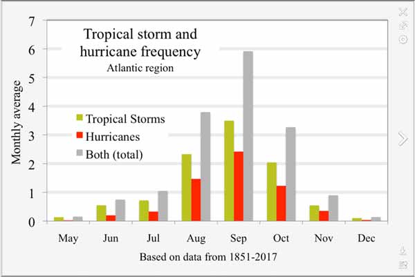
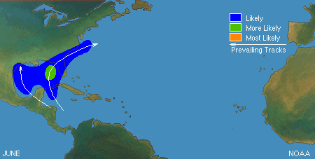
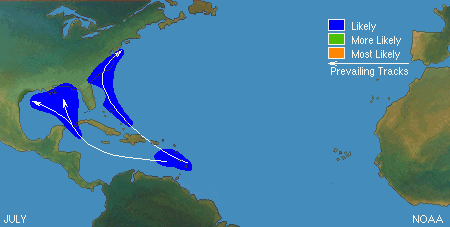
Early storms, April, May, June and late storms, October, November quite commonly start in or near the Caribbean. Mid season, the peak being around August, September, usually start off near Africa.
Here is some general information on hurricanes in Belize:
Historical Information, Hurricane Preparedness Guidelines, Safety Rules, Pet Protection, Assembling a Disaster Kit, and more.....
https://ambergriscaye.com/hurricane/
What Factors Leads To The Development Of Tropical Storms & Hurricanes?I thought I would give everyone some background on what we look for in terms of environmental conditions and other factors that can lead to the development of tropical storms and hurricanes.
There are generally six items (and sometimes more) that we look for in the tropical Atlantic, Caribbean and Gulf of Mexico that are necessary for tropical cyclone development (called tropical cyclogenesis). They are:
1. Ocean water temperatures that are at least 26 degrees Celsius or 79 degrees Fahrenheit to a depth of at least 50 meters or 150 feet.
2. Moist air at about 10,000 feet.
3. A generally unstable atmosphere.
4. An area of enhanced vorticity (spin) which can be caused by low pressure developing or from a tropical wave or tropical disturbance.
5. Weak vertical wind shear.
6. The area of interest has to be at least 5 degrees of latitude away from the equator.
So, let’s look at each item a little more in depth:
1. Ocean Water Temperatures: Normally, ocean water temperatures of at least 26 degrees Celsius or 79 degrees Fahrenheit going down to a depth of at least 50 meters or 150 feet is considered the minimum to form and maintain a tropical cyclone. These warm waters are needed to maintain the warm core that fuels these tropical systems.
2. Moist Air At About 10,000 Feet: The atmosphere at about 10,000 feet above ground level must contain enough moisture to sustain thunderstorms. Dry air in this level of the atmosphere is not favorable to the continuing development of widespread thunderstorm activity. The more humid the air in the atmosphere, the less the disturbance will have to work to moisten the air in order for tropical cyclone genesis to occur.
3. A Generally Unstable Atmosphere: The atmosphere must cool fast enough with height so that the entire atmosphere is unstable and can support thunderstorm activity. It is this thunderstorm activity which allows the heat stored in the ocean waters to be lifted into the atmosphere and used for tropical cyclone development.
Often times during the hurricane season, you hear me talk about hot and dry Saharan air putting a stop to any development chances. The reason why tropical development is unlikely when the Saharan Air Layer (SAL) is an issue is because the hot, dry air puts a lid on any thunderstorm growth. When the mid-levels of the atmosphere (around 10,000 feet) is warmer than the ground, it stops air parcels from rising into the upper atmosphere. Those parcels of air reach a certain point, hit that lid of warmer air and thus stop rising. We call this a stable atmosphere and it is something that tropical cyclones do not like.
Now, the Saharan Air Layer not only puts a stop to any organized thunderstorm growth which could go on to become a tropical cyclone, but it also leads to the atmosphere to be drier. As I mentioned in point number 3, the more humid air, the more likely tropical cyclone genesis may occur; so, if the atmosphere is very dry, like we would see in a SAL outbreak, then the disturbance has to work very hard to moisten up that atmosphere, reducing it’s energy reserve and reducing the likelihood it may become a tropical cyclone.
4. An Area Of Enhanced Vorticity (Spin): Whether it be an area of low pressure embedded within the Intertropical Convergence Zone (ITCZ), a tropical wave, a broad surface front, or an outflow boundary, a low level feature with sufficient vorticity and convergence is required to begin tropical cyclogenesis. Even with perfect upper level conditions and the required atmospheric moisture and instability, the lack of a surface focus will prevent the development of organized convection and a surface low. Bottom line is that tropical cyclones cannot be generated spontaneously. They require at least a weakly organized system that begins to spin and has low level inflow of moist air.
5. Weak Vertical Wind Shear: There must be low values of vertical wind shear between about 5,000 feet (850 millibars) and 35,000 feet (250 millibars) above the ground. I like to look for 20 mph or less of vertical wind shear between those two heights. Vertical wind shear is the rate of change of wind velocity with altitude. Large values of vertical wind shear disrupt the developing tropical cyclone by removing the rising moist air too quickly, preventing the development of the tropical cyclone. Or, if a tropical cyclone has already formed, large vertical shear can weaken or destroy it by interfering with the organization around the cyclone center.
6. Coriolis Force: A minimum distance of 500 kilometers or 310 miles or 5 degrees of latitude away from the equator is normally needed for tropical cyclogenesis. The Coriolis force imparts rotation on the flow and arises as winds begin to flow in toward the lower pressure created by the tropical disturbance. The existence of Coriolis force allows the developing cyclone to achieve gradient wind balance. This is a balance condition found in hurricanes that allows heat and moisture to concentrate near the storm core; this results in the maintenance or intensification of the cyclone if other development factors are neutral.
Even when all of the aforementioned environmental conditions are favorable, a tropical depression still may not form. For this reason, forecasting the genesis of a tropical depression is a very difficult challenge.
Tropical depression formation does begin with a pre-existing disturbance. This disturbance can come from:
Easterly Tropical Waves: These are inverted troughs of low pressure that track westward across the tropical Atlantic. A trough is defined as a region of relatively low pressure. The majority of tropical cyclones form from easterly tropical waves.
West African Disturbance Line (WADL): This is a line of convection, very similar to a squall line, which forms over western Africa and moves into the far eastern Atlantic Ocean. West African Disturbance Lines normally move faster than tropical waves.
TUTT: A TUTT or Tropical Upper Tropospheric Trough is a trough, or cold core low in the upper levels of the atmosphere, which produces convection. On occasion, one of these develops into a warm-core tropical cyclone; however, given that they are cold cored in nature, they can normally take many days to develop into a tropical cyclone as they have to warm up the atmosphere around them.
Old Frontal Boundary: Remnants of an old frontal boundary can sometimes spawn a tropical cyclone on the tail end (southern or southwestern most side) of the front. In general, the most likely time frame for this to happen is during the early part of the hurricane season or the very end of the hurricane season. The most likely area for tropical cyclones to form off of an old front is in the Gulf of Mexico, the western and southwestern Caribbean or immediately offshore of the US Southeast coast.
Mesoscale Convective System: A mesoscale convective complex or MCS is a large complex of thunderstorms that can grow up to 300 miles in diameter and can last for 6 hours or more. Often times, we see a MCS during the spring and summer track across the Great Plains into the central and southeastern United States. Sometimes within a MCS, a mesoscale convective vortex (MCV) can form.
A MCV is a mid-level low pressure system within an MCS that pulls winds into a vortex. Once the main MCS dies, this vortex can persist and can sometimes take on a life of its own, persisting for up to several days after the main MCS has dissipated. There are times that a MCV can move into the Gulf of Mexico or off of the US Southeast coast and become the seedling that causes the development of a tropical storm or hurricane.
In closing, I hope this insight and background into what factors are needed for tropical cyclone formation is helpful. Often times there are more questions than answers when I try to determine whether a tropical disturbance may or may not become a tropical depression.
Crown Weather
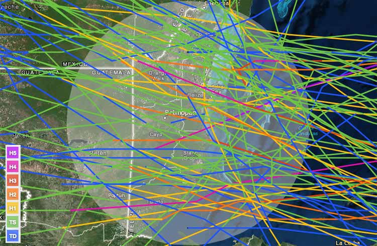
Tracks of the approximately 80 tropical depressions, tropical storms, and hurricanes that have hit Belize since 1851. Image credit: NOAA/CSC.
Belize hurricane history
Belize is often struck by tropical storms and hurricanes. Approximately 80 tropical depressions, tropical storms, and hurricanes have hit Belize since 1851, but it has been five years since the last landfall by a named storm--Tropical Storm Harvey, which hit on August 20, 2011, with 65 mph sustained winds. Harvey's flooding rains killed five people in Mexico, but did little damage in Belize. The last hurricane to hit Belize was Hurricane Richard on October 23, 2010, which made landfall about 20 miles south of Belize's largest city, Belize City (population approximately 100,000--1/3 of Belize's population.) Richard hit as a Category 2 hurricane with 100 mph winds, but was a small hurricane, with hurricane-force winds affecting a region of coast of no more than 20 - 30 miles wide. The hurricane killed one and did about $80 million in damage. The last major hurricane to hit Belize was Hurricane Iris on October 9, 2001, which made landfall in southern Belize as a Category 4 storm with 145 mph winds, killing 35 and doing $250 million in damage.
|
|
|
|
|
Joined: Oct 1999
Posts: 84,404
|
OP

|
NEMO "Hurricane Season 2013" documents
"Reducing the threats from Climate Change, Disaster Preparedness begins with YOU".
National Emergency Management Organization
Melhado Parade, Belmopan
Click Here for NEMO's Emergy Response Information
Are YOU prepared in case of a Hurricane ?
 NEMO encourages Disaster PreparednessThis year the National Emergency Management Organization (NEMO) works under the theme, "Reducing the Threat from Climate Change, Disaster Preparedness begins with you". Senator the Hon. Godwin Hulse in his briefing today was very clear on the “begins with you” part.
Godwin Hulse – Senator:
The state is prepared to assist all the individuals of this country to be safe, in the event of a disaster; prepared to assist, to be a safe as possible. The state cannot and will not save your life, that is for God and we take no such credit. I open with that because too many times, there is the misconception that - "Well, there is a hurricane coming, weh unu di do?" And I want the public who sees this tonight, to understand, it is what you will do for yourself, because it is your responsibility to preserve as best as possible, your own life and to help to prevent accidents to yourself and to look after your property. The state is prepared to assist and will do everything possible to help - is the operative word - that means that when we say it is time to move, get moving. We will not go back to or three times to assist you, if we get there and you say "Chu man, me nu gwen no way." We will not return and my predecessor who carries my same name said - IO said that last year and that is rough. It is not rough, it is factual, because we cannot put the lives of our operatives in danger, when you are resistant to being assisted.
Whenever there is threat of flood or persons need to be relocated due to a storm, the place indentified to provide that temporary safety is known as a Hurricane Shelter. According to Hulse, they cannot guarantee that that shelter will be able to withstand a Category 4 or 5 Hurricane.
Godwin Hulse – Senator:�
We do not guarantee that the shelter you go to will withstand category 4 or 5 hurricanes. As you know, the shelters are schools, churches, community centers, none of which NEMO built. We fund them;this is our Belize. We do not necessarily adhere to all the construction standards that we should. So while NEMO has put its best to ensure that its shelters and reasonably safe, we do not guarantee the shelters. We say they are better than where you live and that is why we ask you to move. Some may be at higher ground and you are subject to flooding and those shelters may not be. Some are better to withstand the winds. Hopefully, as we become a very wealthy nation, hopefully, in my lifetime, we can build some good regional shelters centers that as best as possible, we will not defy God, but we will tell you they will withstand category 5 hurricanes.
The Minister was unyielding in regards to employers who insist on keep employees at work after NEMO has given the advisory for person to be sent home to secure their belonging.
Godwin Hulse – Senator:�
I want to appeal to employers, particularly employers, who are not cognizant with our Belizean culture and particularly many store owners who think that their mighty dollar is better and more important that the lives of our people. When we say that you close and we want your people to go home, they will go home; send them home - that is important to remember. Some years ago, one of the storms in the south, I think it was Iris, a boat operator who thought he could defy God refused to allow some of his employees to go and those who left he said were fired. Thank goodness they left, they preserved their lives; you know the story there. So when we ask you to move, you move. We do not yet have legislations in place and we are working with the Chamber of Commerce and the Unions to see how we can do this. Because we do understand that there is an economic cost, but the importance of life ranks far higher than any economic cost.
A common occurrence which needs to be minimized and discontinued is the reporting of and listening to information from other persons which has not been released by NEMO officials. Senator Hulse says to hear for yourself and listen only to the official report.
Godwin Hulse – Senator:�
Listen to the official and only the official report. My NEC said it's okay to listen to CNN and The Weather Channel and even the local experts, but remember, the official advisory comes from the MET Department, through NEMO. So let us not be our own meteorologist; have our friend next door - "It's a foggy morning, so we know eh wa hot, the breeze nu blow, the coconut tree dey nu di shake." So lets listen to when we get that report, because the local station with our radars and everything monitors that storm exactly. For those of you who are cognizant of The Weather Channel and CNN, they span Belize somewhere from Nicaragua up to the Yucatan Peninsula and we are somewhere in between there, we hardly ever get direct mention and worst they never heard of Crooked Tree, or Hattieville. And I want to appeal, especially to you the media, not to encourage the sideline reporters who are experts; whether they were former meteorological officers or otherwise, it doesn't matter. The official report is coming from our people through NEMO, no disrespect intended.
While the Hurricane Season does not open for another two days we note that two weather systems have already formed; namely Andrea and Barbara. International media reports that Barbara strengthened into a Hurricane just before 2pm yesterday afternoon with maximum sustained winds near 75 mph. Three hours later Barbara made landfall in Oaxaca and Western Chiapas, Mexico where at least two persons have reportedly died. Barbara has now been reduced to a tropical depression as of 5 am Thursday.
PlusTV
|
|
|
|
|
Joined: Oct 1999
Posts: 84,404
|
OP

|
TAKE HURRICANE SEASON PREPARATIONS SERIOUSLY!
NEMO Minister warns, "�when we say it is time to move, get moving. We will not go back two or three times to assist you if you say, 'Cho man, me noh gwine no way.' We will not return!"
Hurricane safety rules:
1. Stay tuned to radio and television stations for regular bulletins.
2. Rely only on official bulletins; do not check these over the telephone.
3. As long as your house is inland and well built-with strong foundations and a good roof, stay at home.
4. Use storm shutters or board windows securely; protect outward door.
5. Stock up on food which has a long shelf life.
6. Check that oil and butane stoves are in working order; replenish stock of kerosene, charcoal and butane.
7. Sterilize baths; all containers and cooking utensils to store water. If in doubt, drink boiled or
treated water only.
8. Keep flashlights, candles and storm lanterns handy along with batteries and matches.
9. Store all garden implements and furniture inside if possible.
10. Lighten foliage of fruit trees near buildings. If very strong winds are likely, remove all coconuts.
11. If you are evacuating, leave early so that you are not stranded by flooded roads, fallen trees, wires and traffic jams and make sure you have enough fuel in your vehicle and follow routes and highways.
12. If there is a lull after the 'eye' of the storm has passed, stay in a safe place, except to make emergency repairs. The wind may return suddenly with even greater strength.
13. Since 90 percent of hurricane casualties occur from drowning, you must evacuate islands and beaches and other vulnerable locations as early as possible.
14. Those seeking shelter should shut off water, gas and electricity before leaving home.
"Reducing the threats from Climate Change, Disaster Preparedness begins with YOU!" That's the theme for this year's hurricane season, which begins Saturday, June 1, 2013 - and that was also the resounding message that came from Minister of Labour, Local Government, Rural Development and National Emergency Management Godwin Hulse at Thursday's press briefing to mark the opening of the 2013 Hurricane Season, which spans June to November.
"Too many times, there is the misconception that� there is a hurricane coming,'Weh unu di do?' And I want the public� to understand, it is what you will do for yourself, because it is your responsibility to preserve as best as possible your own life, and to help to prevent accidents to yourself, and to look after your property. The state is prepared to assist and will do everything possible to help - is the operative word. That means that when we say it is time to move, get moving. We will not go back two or three times to assist you if you say, 'Cho man, me noh gwine no way.' We will not return!" he stated.
"And my predecessor who carries my same name said, 'I said that last year and that is rough'. It is not rough; it is factual, because we cannot put the lives of our operators in danger when you are resistant to being assisted. Let us be very clear," Minister Hulse added.
National Emergency Coordinator Noreen Fairweather gave a reminder of the four main storm phases: "Red One" - there is the threat of a storm within 72 hours; "Phase Two" - storm conditions are expected to impact within 35 to 48 hours; "Phase Three" - the storm is likely to make landfall within the day; and "The Green Phase" - the storm has passed over our country and is no longer a threat.
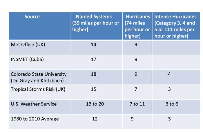
Chief Meteorological Officer Dennis Gonguez noted that based on data obtained between 1980 and 2010, the average number of named storms is twelve. However, this year, as many as 20 systems are predicted by the United States Weather Service and as low as 14 by the met office in the United Kingdom.
Gonguez said that most of the forecasts indicate that approximately 9 systems will develop with winds of 74 miles per hour or higher, which is just about average for the same 1980 -2010 period. Meanwhile, 6 intense systems (categories 3-5 or 111 mph or higher) are forecast for the season.
The 21 names on this year's storm list are Andrea, Barry, Chantal, Dorian, Erin, Fernand, Gabrielle, Humberto, Ingrid, Jerry, Karen, Lorenzo, Melissa, Nestor, Olga, Pablo, Rebekah, Sebastien, Tanya, Van, and Wendy.
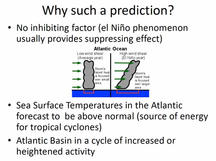
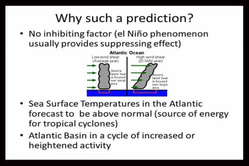
The Chief Met Officer explained that presently there are no inhibiting factors to suppress cyclone activity. Typically, in an El Ni�o year, which is an abnormal warming of the Pacific Ocean, this would serve as an inhibiting effect. However, this year, said Gonguez, there is no El Ni�o.
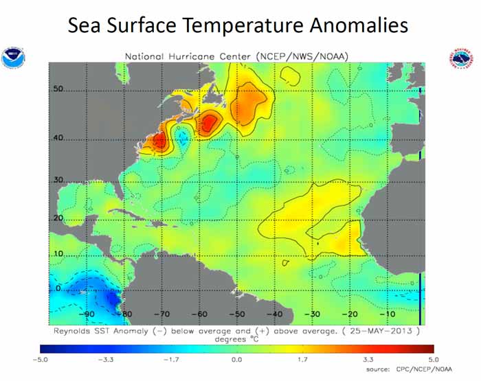
Furthermore, anomalously high sea temperatures in the main development area just off the West Coast of Africa have been observed, and we are at that part of the cycle where there is a heightened level of activity in the Atlantic Basin, Gonguez noted.
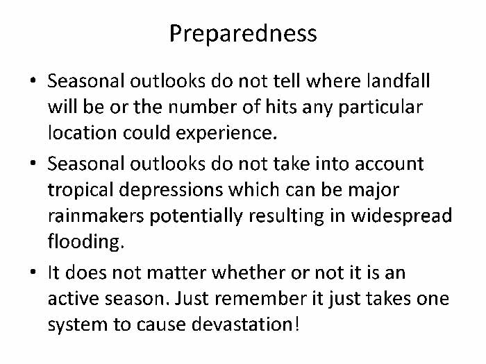
The Chief Met Officer cautioned that forecasts cannot tell exactly where storms will strike. The named storms are distinct from tropical depressions which can result in massive flooding.
Fairweather emphasized that Belizeans should listen for the official advisories from the Belize Met Service, which is the primary source of information. That information is channeled through NEMO, which issues the public advisories.
The public is also advised to seek appropriate shelter early, preferably during daylight hours, Fairweather said. She said that NEMO has designated schools, churches and community centers to keep people safe and dry during major storms.
Minister Hulse issued this caution: "We do not guarantee that the shelter you go to will withstand a category 4 or 5 hurricane. As you know, the shelters are schools, churches, community centers - none of which NEMO built. We found them. This is our Belize. We do not necessarily adhere to all the construction standards that we should. So while NEMO has put its best to ensure that the shelters are reasonably safe, we do not guarantee the shelters. We say they are better than where you live, and that is why we ask you to move. Some may be at higher ground and you're subject to flooding and those shelters may not be. Some are better to withstand the winds."
He also warned employers-particularly some business people who put "the almighty dollar" above human life-that they should not try to keep workers back when national advisories call for business closures.
"When we say you close and we want your people to go home, they will go home. Send them home. That is important to remember. Some years ago, in one of the storms in the South, I think Iris, a boat owner who thought he would defy the order refused to allow some of his employees to go; and those who left, he said, were fired. At least they left, they preserved their life. You know the story there. So when we ask you to move, please move," he stressed.
NEMO says: "Historically, 90 percent of all hurricane casualties have occurred from drowning and 10 percent from other causes. Therefore, it is imperative that all persons should evacuate cayes, beaches and other locations which may be swept by high tides or storm waves. Evacuate to a recommended place of refuge."
The organization also notes that "the highest tide occurs during the second half of the storm and� the rise of the water may take place very rapidly, immediately following the eye of the storm or the time of the lowest barometric pressure."
NEMO advises evacuees to leave early if the only passage to high ground is over a flood-prone road.
"Do not run the risk of being marooned or having to evacuate at the height of the storm amid flying debris," it urges.
More information will be forthcoming. The NEMO team has committed to holding regular media briefings, starting next week. Minister Hulse also spoke of the possibility of alerts being sent to customers via text messages.
Minister Hulse said: "Collectively pray� Remember to always pray."
The Scripture read at the press briefing is Psalm 121: 1-8 - A Song of degrees:
"I will lift up mine eyes unto the hills, from where my help comes. My help comes from [YAHUAH], who made heaven and earth. He will not suffer your foot to be moved: He who keeps you will not slumber. Behold, He that keeps Yisra'el shall neither slumber nor sleep. [YAHUAH] is your keeper: [YAHUAH] is your shade upon your right hand. The sun will not smite you by day nor the moon by night. [YAHUAH] will preserve you [Yisra'el] from all evil: He will preserve your soul. [YAHUAH] will preserve your going out and your coming in, from this time forth and even forevermore."
Amandala
|
|
|
|
|
Joined: Oct 1999
Posts: 84,404
|
OP

|
Hurricane Season in Belize
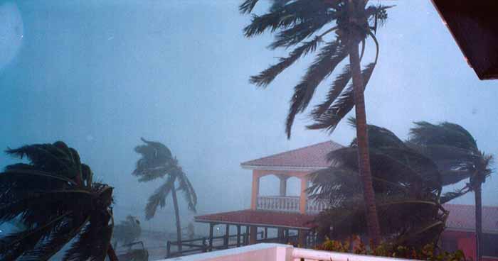
The hurricane season in Belize is well underway and Belizeans remain on watch for storms that may rip through the country like a knife through cloth. Over the last few years, we have been blessed to have all the major hurricanes glide pass us. One would assume that would reassure us, but instead it seems to make many people even more edgy with uncertainty when the hurricane season comes around. Thus each year, we wait to see what will be the outcome of the Belize Hurricane Season.
In Belize, the hurricane season is from June 1st to November 30th. �Despite not having any major storms hit us directly in these months for many years, visitors are urged to keep a keen eye out on the Caribbean as it is often the birthplace for hurricanes destined for our region.
In the past, we have had only about 5 major (above Category 2) hurricanes hit the country during the hurricane season. �However Belize's hurricane scare began in 1931 during the height of the celebration season on the 10th of September (St. George's Caye Day). Belizeans knew nothing about tropical cyclones and their threat to human life. In addition, we did not have a National Weather Bureau to detect and report weather of that magnitude. We had to depend on information given to us from other more developed nations. In this regard, Belizeans were parading and celebrating the anniversary of the Battle of St. George's Caye when disaster struck. The old folks say that the sky became dark, as thick rain clouds began to roll in, then the rains began but because everyone was in such a festive mood, the celebration went on in the rain through the streets of Belize City. Then the sea receded near the Government House in Yarbourough. Many curious Belizeans ran to the location to see the awesome force of nature, ignorant to the danger that would follow. Then the sea returned with such a vengeance that it killed hundreds of onlookers. My grandfather, still a young boy at the time, was saved in a tree after running for dear life with many others. Approximately 2,500 people were killed and more than 50% of homes in the settlement were destroyed. It was a Category 4 and was recorded as the deadliest hurricane in Belize's history.
After 1931, Belizeans began to pay attention to the natural phenomenon known as a tropical cyclone or hurricane as we commonly know it today; but the 1931 hurricane was not the last to strike Belizean soil. In 1955, we had Hurricane Janet which affected Corozal Town. Hurricane Janet was also a Category 4 and it is said that a US Air Force Hurricane Hunter airplane was lost in the storm as it penetrated the eye while Janet was still in the Caribbean. In 1961, we had Hurricane Hattie which demolished Belize City and caused the Father of the Nation to change the capital from Belize City to Belmopan which is on higher grounds. Hattieville, a village just outside Belize City, was named after this hurricane. Then there was Hurricane Greta in 1978. This one hit the southern district of Stann Creek, but due to better detection and preparation, did not result in many deaths. There was Hurricane Iris in 2001 which hit Stann Creek again and was classified a 'monster'. �It was recorded as the strongest of the 2001 Atlantic Hurricane Season. Hurricane Richard in 2010 was the last hurricane to hit Belize and it went straight for Belize's safe haven, Belmopan and its surrounding villages. Richard ripped havoc causing most of the country to lose electricity and costing the country almost BZ$50millon in damages. Apart from those direct hits, were those hurricanes which did not hit, but lingered just long enough near the coast to cause serious damages. They were Mitch, Keith, Chantal and Dean.
Generally speaking, the hurricane season in Belize is intense not because there are many hits, but because many storms come so close to shore. �The hurricane season a time when Belizeans and visitors alike take much needed precaution to minimize loss of life and property. �Here are some things you can expect during a hurricane in Belize:
-
Mention of Saffir-Simpson Hurricane Scale (Categories & Classifications)
-
Flag Signals
-
Preliminary Alert (red flag) – Hurricane may threaten within 72 hours.
-
Red �I Watch (1 red flag with dot) – Hurricane may threaten within 36 hours.
-
Red II Warning (2 red flags with dots) – Hurricane may threaten within 24 hours.
-
All Clear (green flag) – Hurricane has passed.
-
Evacuation of Islands & Coast
-
Flooding
-
Crowded Supermarkets
-
Grocery stores are filled with people trying to stock up on last minute items (food, equipment, shutters, etc). Although illegal, it is not irregular to notice an increase in the cost of goods since shop owners recognize the higher demand.
-
Business & School Closure
-
Flights Grounded
-
Shelters Opened
-
Each district and island have several hurricane shelters. Shelters are for those who think their current boarding is not safe enough or will not withstand the winds, rains, flood associated with the hurricane. Shelters are public. Most only ask for an ID and address to enter.
-
Military Monitoring
-
To maintain peace and order, the military (Belize Defence Force) and police department often are dispersed into the streets to prevent looting, home burglaries, and other illegal activities that may occur.
It is not fair to say that visitors should avoid Belize during the hurricane season, as it is only a matter of being prepared. According to the Caribbean Disaster Emergency Management Agency (CDEMA), here are some other tips when preparing for the hurricane season in Belize:
-
Know your emergency shelter and its exact location
-
Have flashlight with extra batteries, kerosene lamp and/or candles
-
Have portable battery operated radio and extra batteries
-
Have first aid kit and relevant medication
-
Have stock of non-perishable canned food and potable water (enough for 5 days) including baby food (if you have children)
-
Have cash
-
Have sturdy shoes
-
Protect your windows, doors and other glass structures
-
Trim branches from trees
-
Check your home and auto insurance
-
Make arrangements for pets & livestock
-
Develop & have available an emergency communication plan
-
Fuel car
-
Remove outside antennas & satellite dishes
-
Remove from your yard all objects that is likely to become flying hazards
-
Store all valuable documents/papers in waterproof bags high off the ground
During a hurricane we can never be too prepared, but it always helps to be over-informed rather than under-informed, especially during the hurricane season in Belize.
Source
NEMO Preparedness Guidelines
Historically, 90 percent of all hurricane casualties have occurred from drowning and 10 percent from other causes. Therefore, it is imperative that all persons should evacuate cayes, beaches and other locations which may be swept by high tides or storm waves. Evacuate to a recommended place of refuge.
Remember that the highest tide occurs during the second half of the storm and that the rise of the water may take place very rapidly immediately following the eye of the storm or the time of the lowest barometric pressure. If your only passage to high ground is over a road subject to flooding, leave early. Do not run the risk of being marooned or having to evacuate at the height of the storm amid flying debris.
Hurricane Safety Rules:
- Stay tuned to radio and television stations for regular bulletins.
- Rely only on official bulletins; do not check these over the telephone.
- As long as your house is inland and well built-with strong foundations and a good roof, stay at home.
- Use storm shutters or board windows securely, Protect outward door.
- Stock up on food which has a long shelf life.
- Check that oil and butane stoves are in working order- replenish stock of kerosene, charcoal and butane.
- Sterilize baths; all containers and cooking utensils to store water. If in doubt, drink boiled or
- treated water only.
- Keep flashlights, candles and storm lanterns handy along with batteries and matches.
- Store all garden implements and furniture inside if possible.
- Lighten foliage of fruit trees near buildings. If very strong winds are likely, remove all coconuts.
- If you are evacuating, leave early so that you are not stranded by flooded roads, fallen trees, wires and traffic jams and make sure you have enough fuel in your vehicle and follow routes and highways.
- If there is a lull after the 'eye' of the storm has passed, stay in a safe place, except to make emergency repairs. The wind may return suddenly with even greater strength.
- Since 90 percent of hurricane casualties occur from drowning, you must evacuate islands and beaches and other vulnerable locations as early as possible.
- Those seeking shelter should shut off water, gas and electricity before leaving home.
Note: Pets are not allowed at shelters, you need to make your own arrangements for the safety of your pets. Hurricane probability chart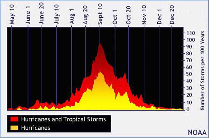
|
|
|
|
|
Joined: Oct 1999
Posts: 84,404
|
OP

|
NEMO HURRICANE AWARENESS SIGNS GO UP IN SAN PEDRO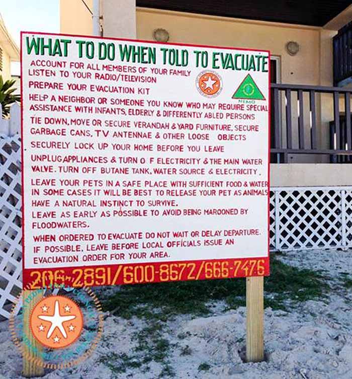
|
|
|
|
|
Joined: Oct 1999
Posts: 84,404
|
OP

|
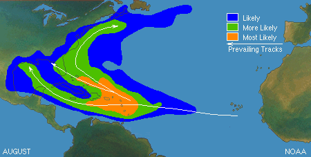
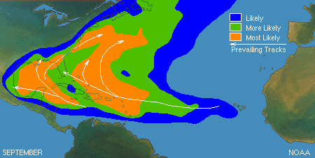
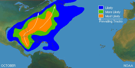
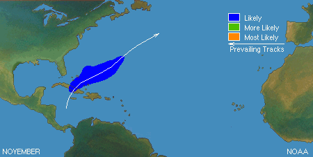
Typical Tropical Cyclone Origins & Track By MonthDepending on the time of year, tropical storms and hurricanes develop in different areas of the tropical North Atlantic. In the Atlantic Basin (the North Atlantic Ocean, the Gulf of Mexico, and the Caribbean Sea), hurricane season reaches its peak between mid-August and October.
How To Prepare For Hurricane Season
Long before a hurricane forms, there are things you can do to get ready if a storms heads your way.
|
|
|
|
|
Joined: Oct 1999
Posts: 84,404
|
OP

|
Mr. Harry Cain Season Is Here
By G. Michael Reid
O God, Master of this passing world, hear the humble voices of your children. The Sea of Galilee obeyed your order and returned to its former quietude; you are still the Master of land and sea. We live in the shadow of a danger over which we have no control. The Gulf, like a provoked and angry giant, can awake from its seeming lethargy, overstep its conventional boundaries, invade our land and spread chaos and disaster. During this hurricane season, we turn to You, O loving Father. Spare us from past tragedies whose memories are still so vivid and whose wounds seem to refuse to heal with the passing of time�. so that spared from the calamities common to this area and animated with a true spirit of gratitude, we will walk in your footsteps to reach the heavenly Jerusalem where a storm-less eternity awaits us. ~ from a prayer dedicated to the victims of Hurricane Audrey in 1957.
We are just a little into the start of the 2016 Hurricane Season and it seems that we have shot out the gate in a hurry. This year saw the development of not only one but two storms that reached hurricane status as early as January with Alex forming over the Atlantic and Hurricane Pali forming over the Central Pacific. It is the first time since records began being kept in 1851 that two such storms have occurred so early and let us hope it is no harbinger of things to come.
With this in mind, it seemed apropos to shed a little light on this deadly nonpareil that threatens us each year from June to November. Of course, while those six months are considered the official Hurricane Season, we are warned each year that hurricanes can actually form in any month; as is evident by the formation of Alex and Pali in January of all months. We nonetheless count our blessings, because except for the occasional tremor, we are spared the threat of earthquakes, volcanoes, tornadoes and the other natural disasters that plague other parts of the world. Ole Mr. Harry Cain of course, offers enough drama on its own.
For the earliest since hurricanes began being named, we also reached the letter "C", as Hurricane Colin spawned heavy rains over Florida last week. Fortunately, not much havoc was wreaked by either storm and Colin was described as "primarily a rainmaker". With our little country so prone to flooding, blackouts and other storm related hazards, even such rainmakers make us nervous and send us bustling and stocking up on supplies.
Hurricanes are a potentially deadly phenomenon and might be the only thing that strikes more fear in the hearts of Belizeans than a Guatemalan invasion. While Belize has been hit by quite a few storms in our relatively brief existence, two storms in particular remains etched in the annals of our history; an unnamed storm of 1931 and of course, Hurricane Hattie which struck on October 31st 1961.
Each year when these storms threaten, we give thanks for the incredibly foresight of the Father of our Nation who saw it fit to buck criticism and move our capital inland. Belmopan has been a saving grace and apart from being a refuge from storms, it has grown into quite the cuddly little paradise of its own. Unfortunately, lately it has also become plagued by the terrible scourge of crime that ravages the rest of our nation. Fix it people, fix it!
Hurricanes are generally "a rotating, organized system of clouds and thunderstorms that originates over tropical or subtropical waters and has closed low-level circulation". It is the end process of a cycle that begins with a tropical depression and evolves into a tropical storm and then a hurricane. Once a storm reaches a sustained wind speed of 39 miles per hour it is considered a tropical storm and is given a name. Once the winds achieve a sustained speed of 74 miles per hour, it is considered a hurricane and retains the name given to the tropical storm. The ingredients for a hurricane include warm tropical seas, moisture, and a little wind. If these conditions persist for any period of time, they combine to produce "violent winds, incredible waves, torrential rains, and floods". We know too well about these, don't we?
Hurricanes spin in different directions depending on which side of the equator they are formed. They spin to the left (or clockwise) in the southern hemisphere and to the right (counter-clockwise) in the northern hemisphere. This is caused by what is considered a "super-powerful phenomenon" known as the "Coriolis Effect". This is what deflects moving objects to either the right or the left depending on which side of the equator you are on. And they say there's no GOD!!!!
Hurricanes are called by different names depending on geographical locations. In the Atlantic and Northern Pacific they are called hurricanes while in the Northwest Pacific they are called typhoons. In the South Pacific and Indian Ocean they are called cyclones. They are all generally the same which is Suffice to say, very dangerous animals.
Although the credit for giving names to storms is bestowed upon Australian meteorologist Clement Wragge, there are records of storms being named for hundred years of years before Wragge who retired in 1907. Hurricanes were first named after the saint on whose day they would occur. For example the infamous San Felipe Hurricane which hit the island of Puerto Rico on September 13th, 1876. Incredibly enough, another storm also named San Felipe again hit Puerto Rico and again on September 13th, this time 52 years later in 1928; go figure!
In 1951, meteorologist in the United States began naming storms by the phonetic alphabet of Able, Baker, Charlie, etc. but found it too confusing when a new, international phonetic alphabet was introduced. Two years later, that practice was abandoned in favour of naming storms exclusively with women's names. As could be expected, they eventually ran into problems with that and in 1979 were forced to begin adding male names to the list.
Using male names might have had an unexpected advantage since in an interesting study conducted at the University of Illinois, researcher Sharon Shavitt found that people actually took storms with female names less seriously. That, according to Shavitt, invariably put lives at risk. Needless to say, she has been assailed, in particular by feminists critics. Shavitt is sticking by her findings however.
Here's another interesting fact that might create some stir. There are phases of the oceans temperature that are called El Nino and La Nina (no space to explain those, you'll have to look them up). But while El Ni�o occurs more frequently than La Ni�a, in an article published in the Amandala of last May under the title "Analyzing 60 years of Belize hurricane history", our very own Frank Tench revealed an interesting statistic. According to data compiled between 1954 and 2014, there was all of one (1) hurricane during El Nino years as opposed to, count them, twelve (12) during the years of La Nina. According to Tench, as a general rule fewer tropical storms form over the Tropical Atlantic and Caribbean during El Ni�o episodes when compared to La Nina. Go tackle Frank, not me.
Fun and jokes aside folks, we need to vigilant and prepared. Experts are predicting an above average number of storms for this year and with us forever being in licks way, any number might play. Stock on your can foods, candles and check the batteries in the flashlights. May GOD spare us again this year and may we always be blessed!
The Belize Times
HURRICANE PREPAREDNESS BY EXPERIENCE
IN MY QUIET MOMENTS, I LIKE TO SHARE EXPERIENCES THAT WE WENT THROUGH IN DAYS GONE BYE.
In days gone bye, the government of Belize had a Preparedness Plan, in the eventuality of an approaching Storm.
The FIRST Step was, to prepare all hurricane shelters with, A Stand-Bye generator, sufficient water for three days and sufficient working toilets.
SECOND Step was to prepare for quick evacuation of people from low lying areas in Belize City and in Rural Areas. Bus Owners were notified and Fuel Pumps were advised to be ready.
SECOND Step was all patients at the Hospitals, at Old Folks Centers were transported to INLAND accomodations.
FOURTH Step was to send large metal barges to the upper Belize River, to fill with fresh water, for after the storm. There were some large Yellow Aluminum VATS, that were strategically placed in various areas of the City.
THE POLICE AND MILITARY WERE PLACED ON EMERGENCY ALERT.
These are STEPS that were relevant THEN as they are NOW.
Every year, AROUND THIS TIME, I like to REHEARSE my past EXPERIENCES.
TWO EXPERIENCES THAT COME VIVID IN MY MIND WERE, WHEN.
1. Hurricane Hattie struck Belize City in 1961. Some of the Stand Bye Generators had not been serviced.
On the night of the Storm, the generator at the Old Hospital gave up suddenly. Early in the morning Premier Price called me through the police Net Work. to send a Stand Bye LISTER Light Plant that we had at our Station In San Ignacio..
2. THEN, when Monstrous, Hurricane Mitch was heading our way, the Novelo's Convention Hall in Santa Elena, was sheltering some 600 persons, mostly from Belize City. But the experts forgot to supply the place with common TOILET PAPER .
The morning after the Storm, it was a disaster around that Shelter. Despite that you tell people to bring their needs, please be prepared because many will not bring. _- And you cannot ignore this one.
I think Melchor saved the day with this possible catastrophe.
Remember, who feels it knows it. Experiences educate us. We went through these and many more sad experiences, which wemust pass on to the younger ones.
Hector Silva
|
|
|
|
|
Joined: Oct 1999
Posts: 84,404
|
OP

|
HERE ARE SOME TERMS YOU MAY SEE HERE DURING THE HURRICANE SEASON:Centre: The central position of a system at the surface...usually defined by the location of minimum wind or minimum pressure. Eyewall: An organized band or ring of cumulonimbus clouds that surround the eye, or light-wind CENTRE of a tropical cyclone. Hurricane: A tropical cyclone in which the maximum sustained surface wind is more than 73 mph. Hurricane Warning: An announcement that sustained winds of more than 73 mph associated with a tropical cyclone are expected somewhere within the specified area within 36 hours Hurricane Watch: An announcement that sustained winds of more than 73 mph associated with a tropical cyclone are possible within the specified area within 48 hours Invest (Investigative Area): An area of disturbed weather being investigated for potential tropical cyclone development by collecting specialized data ITCZ (Inter-Tropical Convergence Zone): An area that encircles the globe near the equator where the northeast trade winds from the northern hemisphere converge with southeast winds from the southern hemisphere and forces the air up into the atmosphere Major Hurricane: A hurricane classified as Category 3 or higher (above 110 mph) Maximum Sustained Surface Wind: The highest one-minute average wind associated with a system at a particular point in time. Potential Tropical Cyclone: A disturbance that is not yet a tropical cyclone, but poses the threat of bringing tropical storm or hurricane conditions to land areas within 48 hours. Rapid Intensification: An increase in the maximum sustained winds of a tropical cyclone of at least 34 mph in a 24hr period. Storm Surge: An abnormal rise in sea level accompanying an intense storm, and whose height is the difference between the observed level of the sea surface and the level that would have occurred in the absence of the cyclone. Storm surge is usually estimated by subtracting the normal or astronomic high tide from the observed storm tide. Tropical Cyclone: A warm-core non-frontal synoptic-scale cyclone, originating over tropical or subtropical waters, with organized deep convection and a closed surface wind circulation about a well-defined center. Once formed, a tropical cyclone is maintained by the extraction of heat energy from the ocean at high temperatures and heat export at the low temperatures of the upper troposphere. Tropical Depression: A tropical cyclone in which the maximum sustained surface wind speed is 38 mph or less. Tropical Disturbance: A discrete tropical weather system of apparently organized convection...generally 100 to 300 nm in diameter - originating in the tropics or subtropics, having a non-frontal migratory character, and maintaining its identity for 24 hours or more. Tropical Storm: A tropical cyclone in which the maximum sustained surface wind speed ranges from above 38 mph to 73 mph Tropical Storm Warning: An announcement that sustained winds between 38 and 74 mph associated with a tropical cyclone are expected somewhere within the specified area within 36 hours Tropical Storm Watch: An announcement that sustained winds between 38 and 74 mph associated with a tropical cyclone are possible within the specified area within 48 hours Tropical Wave: A trough or cyclonic curvature maximum in the trade-wind easterlies. The wave may reach maximum amplitude in the lower middle troposphere. ============== Storms Pet SafetyA few tips for keeping your pets safe at home during the storms that are heading our way. We also noticed that some locals had taken the initiative to just throw their pets over our shelter fences when this storm was announced. We would like to encourage everyone to not do so as we are struggling to find a proper shelter for them during this storm. Keep in mind that we currently are housing 50+ dogs and 60+ cats. If you may have an issue with where to keep your pet give us a call so we can assist you with your problems the best we can. SAGA ![[Linked Image]](//Ambergriscaye.com/art9/312589799_10162116307022785_9090136357965290252_n.jpg)
|
|
|
|
S |
M |
T |
W |
T |
F |
S |
|
|
|
|
|
|
|
1
|
|
2
|
3
|
4
|
5
|
6
|
7
|
8
|
|
9
|
10
|
11
|
12
|
13
|
14
|
15
|
|
16
|
17
|
18
|
19
|
20
|
21
|
22
|
|
23
|
24
|
25
|
26
|
27
|
28
|
|
|
|
0 members (),
123
guests, and
0
robots. |
|
Key:
Admin,
Global Mod,
Mod
|
|
|
Forums44
Topics79,226
Posts500,087
Members20,578
| |
Most Online7,413
Nov 7th, 2021
|
|
|
|

