...NOAA HURRICANE HUNTER PLANE INDICATES ISAAC HAS DISSIPATED... ...THIS IS THE LAST ADVISORY...
500 AM EDT Sat Sep 15 2018
A NOAA Hurricane Hunter aircraft investigated Isaac over the past
few hours and was unable to identify a well-defined center. The
plane found multiple small and poorly-defined circulations embedded
within a larger area of weak and variable winds, well to the south
of the previous estimated center location. The plane also found that
the minimum pressure has risen to around 1006 mb. All of this data
confirmed what two late-arriving ASCAT overpasses from earlier this
evening indicated, that Isaac has opened up into a southwest to
northeast oriented trough. Since Isaac does not have a well-defined
center, it no longer meets the NHC definition of a tropical cyclone
and this is the last advisory.
The strongest SFMR winds found by the plane were around 30 kt,
mainly to the north of the deep convection, so the intensity has
been set at that value. Although some of the regional hurricane
models suggest that small short-lived circulations like the ones
found by the plane could temporarily spin up within the larger
envelope of the tropical wave over the next several days, none of
the dynamical models currently show any significant redevelopment of
Isaac. The wave will likely continue westward across the Caribbean
Sea over the next few days, producing gusty winds and occasional
heavy rains over portions of Hispaniola and Jamaica.
This is the last public advisory issued by the National Hurricane
Center on Isaac.
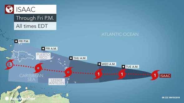
There is the potential for Isaac to strengthen to a tropical storm or hurricane while crossing the western Caribbean and entering the Gulf of Mexico next week.
Isaac became a tropical rainstorm early Saturday morning, but just because it has lost its tropical storm status does not mean it should be ignored.
"The key will be how much wind shear Isaac encounters along the way and if Isaac manages to avoid much interaction with large land areas such as Mexico's Yucatan Peninsula and Cuba," Kottlowski said.
Wind shear is the increase in wind speed with altitude or over horizontal distance. Strong wind shear can prevent a tropic storm from forming and cause a hurricane to weaken. A small amount of wind shear can vent a tropical storm or hurricane and cause it to strengthen.
"Some minor fluctuation in organization and strength is likely over the Caribbean into early next week, but it is from Tuesday on, as it nears and passes through the Yucatan Channel, that we really have to keep an eye on it," Kottlowski said.

TS Issac, Going From Strength To Weakness
As we go into the weekend, some may be wondering what's going to happen with Tropical Storm Isaac. Well, at 3:00 this afternoon, the storm which had weakened to a Depression has become a minimal storm again with maximum winds of 40 miles per hour.
But, there's not much prospect for development and the National Hurricane Center says the future of this system is unclear. It continues to move westward at 14 miles per hours, but a turn to the west-northwest is possible by late Sunday. The present forecast track seems to be taking it more towards the south of Jamaica by early next week.
But, the Hurricane Center reports that while it has re-gathered some strength - little change in strength is forecast during the next 36 hours - and the storm is forecast to again weaken to a tropical depression by Sunday and degenerate into a wave by Monday. But, this is just a forecast, and anything could happen - so we all have to keep watching this system
Channel 7
For more information, check the daily Tropical Weather Outlook, click here.


![[Linked Image]](http://Ambergriscaye.com/art7/isaac180916b.jpg)


